Runic inscription Ladbrostenen, U114, L2017:4956 in Ed parish, Upplands Väsby municipality
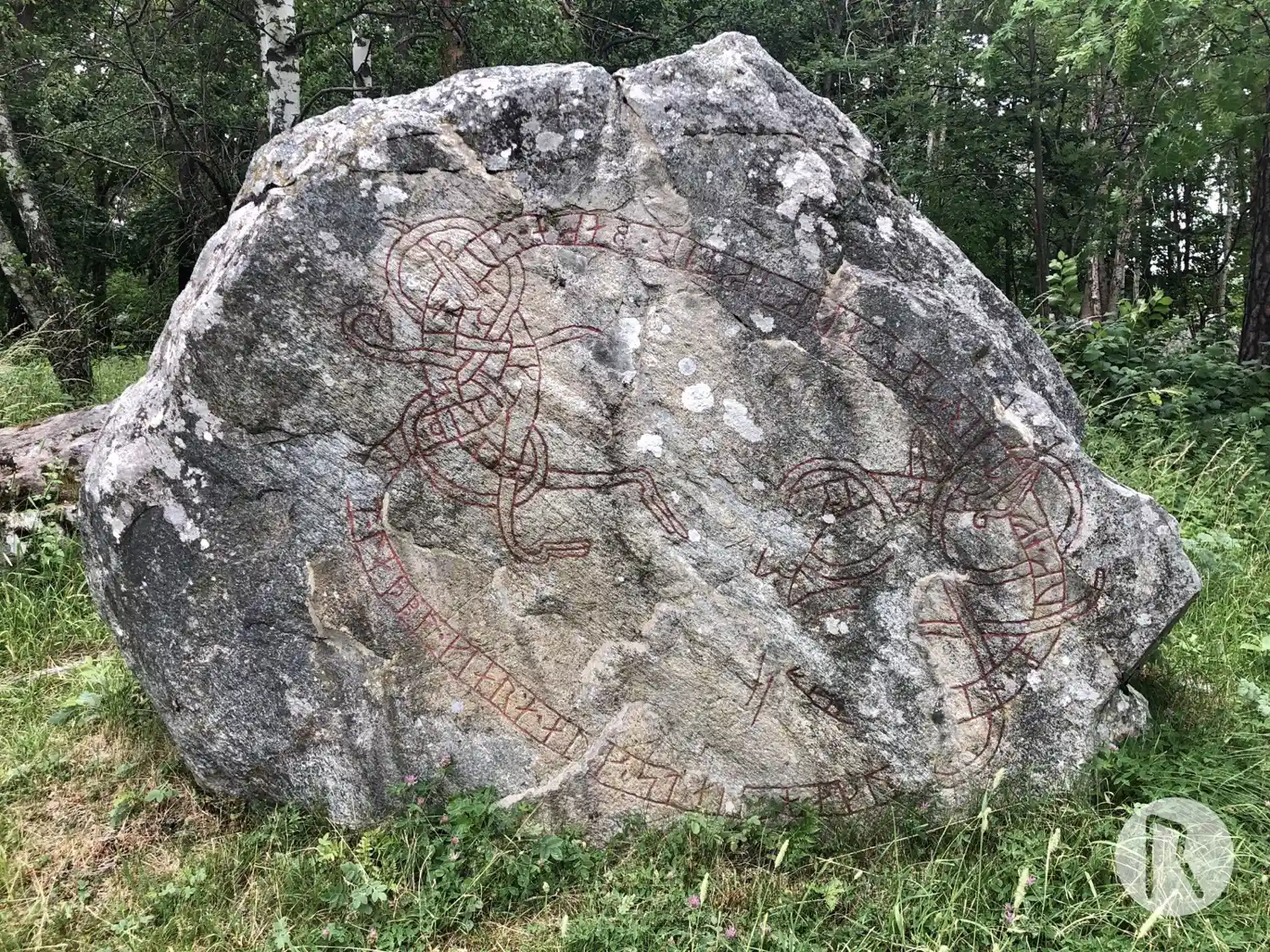
Photo: Niklas Vackerdag
Runic inscription
§A ikriþ ' l[i]t · laþbo · kiara ' auk · stain · haku[a eftir] ikim[a]r (b)(o)[ta s]in · auk · eftar · tan · auk · eftir · baka · suni · sina §B ' þaiR byku ' i rynby ' auk ' bo atu ' [kr]istr · ialbi ' s(a)(l)(u) · þai[r- ·] (þ)it skal ' at minum · mana ' miþan · min li[fa]
Inscription
§A ikriþ ' l[i]t · laþbo · kiara ' auk · stain · haku[a eftir] ikim[a]r (b)(o)[ta s]in · auk · eftar · tan · auk · eftir · baka · suni · sina §B ' þaiR byku ' i rynby ' auk ' bo atu ' [kr]istr · ialbi ' s(a)(l)(u) · þai[r- ·] (þ)it skal ' at minum · mana ' miþan · min li[fa]
Translation
§A Ingríðr had the causeway made and the stone cut in memory of Ingimarr, her husbandman, and in memory of Danr, and in memory of Banki/Baggi(?), her sons. §B They lived in Runbýr and owned the estate. May Christ help their souls. That will (stand) in memory of the men while man lives.
Find the carving
Runic inscription Ladbrostenen, U114, L2017:4956 in Ed parish, Upplands Väsby municipality
Facts
| Monument number | L2017:4956 |
|---|---|
| Swedish National Heritage Board ID | Ed 45:1 |
| Status | Confirmed on location |
| Place | Visible above ground |
| Period | Viking age |
| Antiquarian assessment | Ancient monument |
| Damage status | Damage |
| County | Stockholm |
| Municipality | Upplands Väsby |
| Parish | Ed |
| Coordinates | 59.524872, 17.900313 |
Sources
Most of the factual information in Runkartan comes from the Swedish National Heritage Board’s Fornsök data and from the Scandinavian Runic Text Database. The maps come from OpenStreetMap and Leaflet.js. The photographs were taken by the credited photographers.