Piedra rúnica Öl37, L1956:1917 en Runsten parroquia, Borgholm municipio
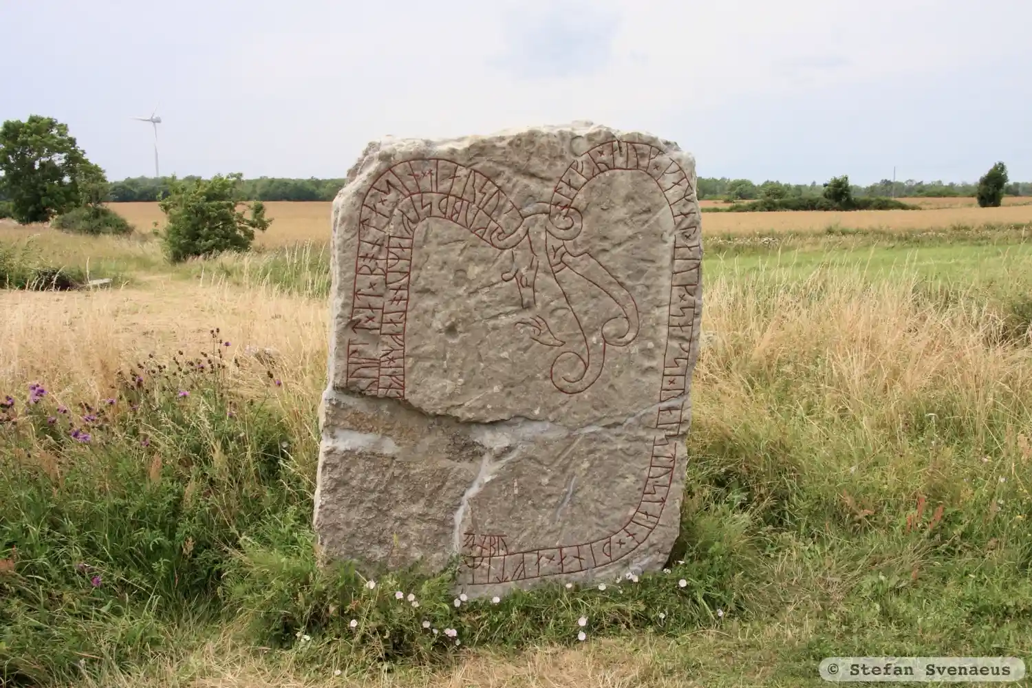
Foto: Stefan Svenaeus
Inscripción rúnica
§P olafR × auk × kamal × auk × sagsi × raistu + stain × þina × aftiR × [un × faþur × sin × kai](R)ui lit × at × bonta × sin × hiarsu[k] kubl þsi fiaRun olafR hefnt[i at miomu ati un hiar hal](f)an by §Q olafR × auk × kamal × auk × sagsi × raistu + stain × þina × aftiR × [un × faþur × sin × kai](R)ui lit × at × bonta × sin × hiarsu[k] kubl þsi fiaRun olafR hefnt[i at miom| |mu ati un hiar hal](f)an by
Inscripción
§P olafR × auk × kamal × auk × sagsi × raistu + stain × þina × aftiR × [un × faþur × sin × kai](R)ui lit × at × bonta × sin × hiarsu[k] kubl þsi fiaRun olafR hefnt[i at miomu ati un hiar hal](f)an by §Q olafR × auk × kamal × auk × sagsi × raistu + stain × þina × aftiR × [un × faþur × sin × kai](R)ui lit × at × bonta × sin × hiarsu[k] kubl þsi fiaRun olafR hefnt[i at miom| |mu ati un hiar hal](f)an by
Traducción
§P Ólafr and Gamall and Saxi raised this stone in memory of Unn, their father. Geirvé had these monuments (raised) here in memory of her husbandman. Ólafr avenged Féar-Unn (Rich-Unn) at Mon(?). Unn owned here half the village. §Q Ólafr and Gamall and Saxi raised this stone in memory of Unn, their father. Geirvé had these monuments (raised) here in memory of her husbandman. Ólafr avenged Féar-Unn (Rich-Unn) in the middle of the heath(?). Unn owned here half the village.
Encontrar la talla
Piedra rúnica Öl37, L1956:1917 en Runsten parroquia, Borgholm municipio
Datos
| Número del monumento | L1956:1917 |
|---|---|
| Designación de la Dirección Nacional del Patrimonio | Runsten 33:1 |
| Estado | Confirmado en campo |
| Ubicación | Visible sobre el suelo |
| Material | Caliza gris con ortoceras |
| Valoración antiquaria | Monumento antiguo protegido |
| Estado de daños | Daño |
| Provincia | Kalmar |
| Municipio | Borgholm |
| Parroquia | Runsten |
| Coordenadas | 56.718602, 16.709374 |
Fuentes
La mayoría de los datos factuales de Runkartan proceden de los datos Fornsök de la Dirección Nacional Sueca del Patrimonio y de la Base de Datos Escandinava de Textos Rúnicos. Los mapas proceden de OpenStreetMap y Leaflet.js. Las fotografías fueron tomadas por los fotógrafos indicados.